In a world where convenience is key, efficient route planning has become essential to our daily lives. While Google Maps has long been the go-to navigation tool for many, several alternatives offer unique features and advantages.
Whether you’re looking for alternatives due to privacy concerns or specific navigation features or are exploring new options, we’ve curated a list of the eight best alternatives to Google Maps. Join us as we navigate these alternatives, each offering benefits to enhance your route planning experience.
From real-time traffic updates to innovative route suggestions, these alternatives may change how you navigate the world. Let’s dive into the world of mapping options beyond the familiar confines of Google Maps.
Why Look for an Alternative to Google Maps?
Exploring alternatives to Google Maps has become necessary for many users due to various drawbacks and limitations within the platform. While Google Maps is undeniably a popular and reliable navigation tool, certain concerns have prompted individuals and businesses, particularly those in logistics, to seek alternative solutions.
1. Navigation Issues
Some logistics professionals have voiced concerns about the accuracy of Google Maps, especially in intricate urban landscapes. Users report inaccurate turn-by-turn directions, potentially causing delays and inefficiencies in the logistics chain.
2. Inaccuracies in Remote Locations
In remote or less densely populated areas, Google Maps may exhibit inaccuracies. Logistics companies operating in rural or developing regions need a mapping solution that excels in providing precise directions, especially where traditional landmarks are sparse.
3. Limitations in Offline Use
Another reason to look for Google Maps alternatives is that it has limitations in functionality when used without an internet connection. This can pose challenges in logistics, where connectivity may not be guaranteed, and real-time updates are critical for route optimization.
4. Lack of Real-Time Construction Alerts
Navigating through construction zones is a common challenge in logistics. Google Maps falls short in providing real-time construction alerts, potentially leading drivers into unexpected roadblocks or delays.
5. No Real-time Tracking of Field Reps or Drivers
For logistics companies, real-time tracking of field representatives or drivers is crucial for monitoring delivery progress and ensuring timely arrivals. Google Maps lacks robust features for real-time tracking, leaving a gap in logistical visibility for businesses.
6. Licensing and Usage Restrictions
While Google Maps is widely accessible, its licensing and usage restrictions can pose challenges for logistics companies with specific needs. Some users have reported limitations in integrating Google Maps into proprietary logistics software or facing unexpected usage restrictions.

8 Best Google Maps Alternatives
1. Detrack: Best all-in-one platform for logistics and supply chain
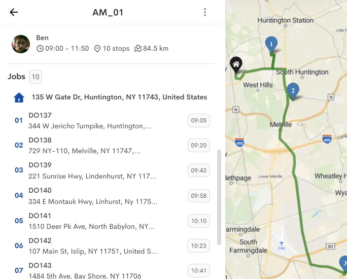
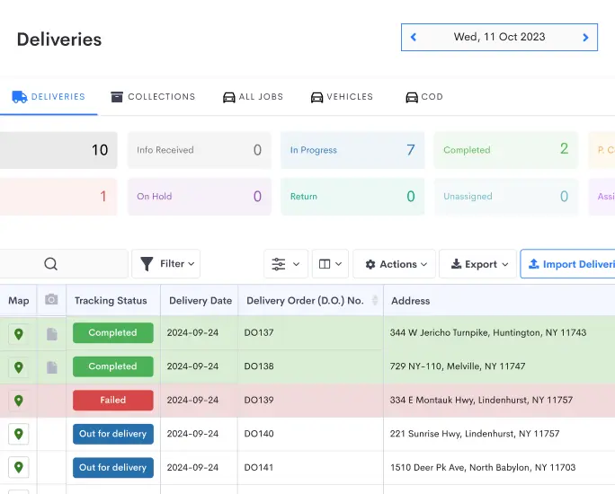
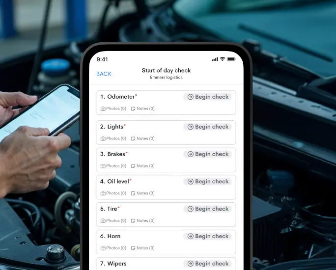
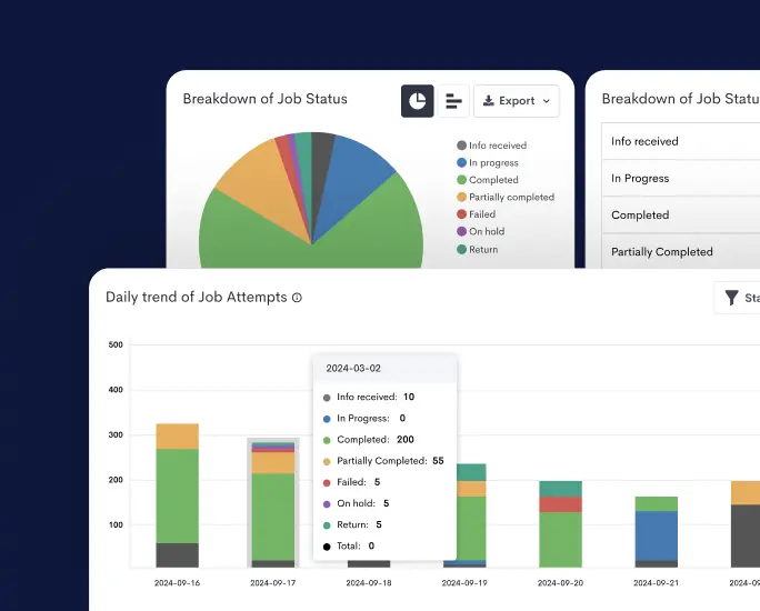
Brief description: Detrack stands out as an all-encompassing logistics and supply chain platform designed to optimize delivery operations with real-time visibility and analytics. This cloud-based solution enhances efficiency, offering a user-friendly interface for seamless integration into logistics workflows.
Top Features
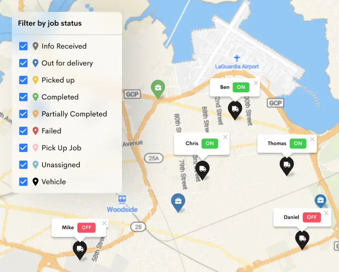
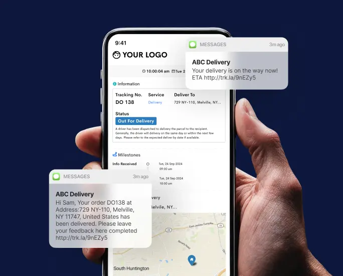
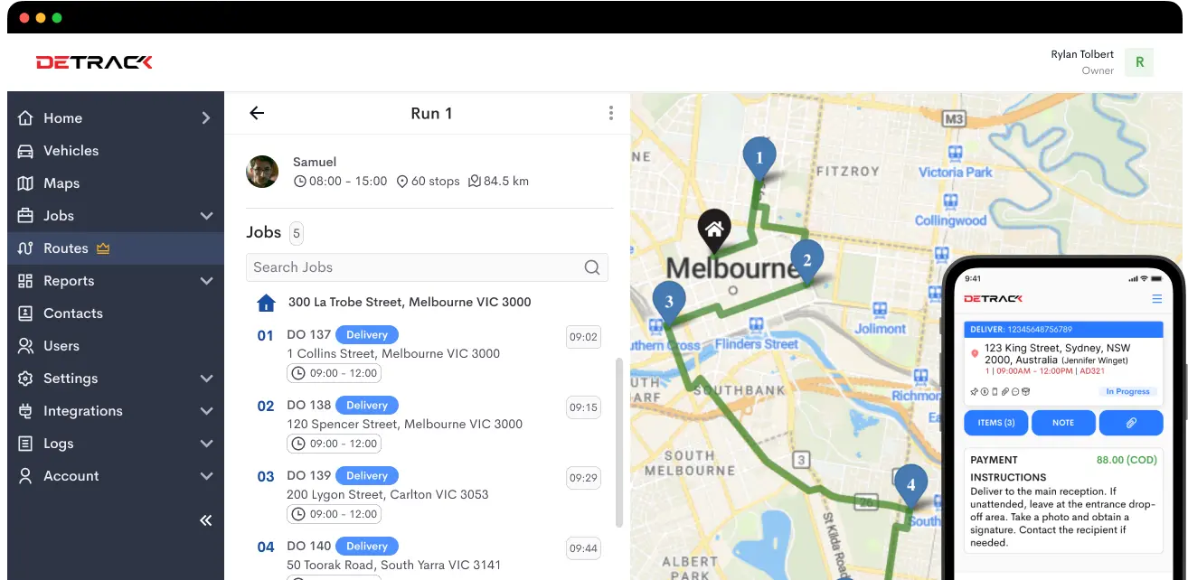
- Real-time Tracking: Detrack enables live monitoring of deliveries, ensuring complete visibility throughout the supply chain.
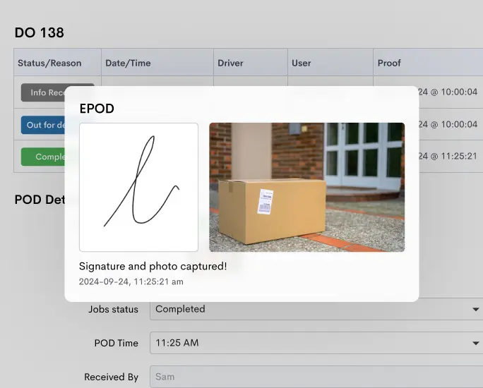
- Electronic Proof of Delivery: Capture digital signatures and photos, providing concrete evidence of successful deliveries.
- Route Optimization: Enhance efficiency by optimizing delivery routes, minimizing delays, and improving overall logistics performance.
Pros
👍 User-friendly Interface: Detrack’s intuitive interface facilitates easy adoption for logistics professionals.
👍 Comprehensive Tracking: The platform offers in-depth tracking capabilities, providing real-time insights into delivery progress.
👍 Integration: Detrack seamlessly integrates with various e-commerce platforms, streamlining business operations.
Cons
👎 Pricing: Some users may find Detrack’s pricing relatively higher, although the comprehensive feature set justifies the investment.
Pricing
Visit Detrack Pricing for detailed pricing information.
Routes Giving You a Rough Ride?
Glide through your deliveries with Detrack’s optimized routing, reducing transit time and fuel costs.
Try 14 Day Free Trial
2. Apple Maps: Best for Siri and iOS integrations
Brief description: Another alternative to Google Maps is Apple Maps. Apple Maps, a default navigation tool for iOS users, delivers a seamless mapping experience with a distinct focus on user privacy. Integrated with Siri and deeply connected to the iOS ecosystem, it provides an efficient and secure navigation solution for Apple device users.
Top Features
- Siri Integration: Users benefit from voice-guided navigation through Siri, enhancing hands-free control.
- Privacy-Focused: Apple Maps prioritizes user data security, ensuring a private and secure navigation experience.
- iOS Ecosystem Integration: Seamlessly syncs with other Apple devices, providing a cohesive and interconnected user experience.
Pros
👍 Tight Integration: Apple Maps is deeply integrated into the iOS ecosystem, offering a cohesive experience for Apple device users.
👍 Privacy-Centric: Users appreciate Apple’s commitment to data security and privacy.
👍 Smooth Interface: The user-friendly interface provides a smooth and visually appealing navigation experience.
Cons
👎 Limited Cross-Platform Availability: Apple Maps is primarily designed for iOS, limiting its availability on other platforms.
Pricing
Pre-installed on Apple devices, no separate pricing.
3. Waze: Best for Real-Time Traffic and Road Alerts
Brief description: Waze, a community-driven navigation app, distinguishes itself by harnessing real-time traffic and road information contributed by its user community. Offering dynamic route adjustments and active community engagement, Waze provides a unique and interactive navigation experience.
Top Features
- Real-Time Traffic Updates: Waze relies on crowdsourced data to deliver up-to-the-minute traffic information.
- Community-Driven Alerts: Users actively report road incidents, contributing to a dynamic and responsive navigation system.
- Dynamic Route Adjustments: Waze provides alternative routes based on real-time traffic conditions.
Pros
👍 Excellent Real-time Traffic Information: Users appreciate the accuracy and timeliness of Waze’s real-time traffic updates.
👍 Active Community Engagement: The Waze community actively contributes to the accuracy of road information.
👍 Efficient Rerouting Options: Waze dynamically adjusts routes to optimize for current traffic conditions.
Cons
👎 Learning Curve: Some users may find Waze to have a steeper learning curve compared to other navigation apps.
Pricing
Free to use.
4. MapQuest: Best for Detailed Route Planning and Optimization
Brief description: MapQuest is an alternative to Google Maps that distinguishes itself by offering detailed route planning and optimization features, making it an ideal choice for users who prioritize precision in mapping and navigation.
Top Features
- Detailed Maps: MapQuest provides extensive mapping data for comprehensive route planning.
- Route Planning: Users can customize routes to suit specific requirements, optimizing for efficiency.
- Offline Maps: MapQuest allows access to maps without an internet connection, ensuring functionality in areas with limited connectivity.
Pros
👍 Detailed Route Customization: MapQuest stands out for its detailed and customizable route planning capabilities.
👍 User-friendly Interface: The interface is intuitive, catering to a broad user base.
👍 Offline Map Access: MapQuest’s offline functionality ensures uninterrupted access to maps in areas with limited connectivity.
Cons
👎 Ad-Supported: Some users find the presence of ads to be distracting during navigation.
Pricing
Free with optional ad-free subscription.
5. OsmAnd: Best for Offline Mobile Navigation with Detailed Maps
Brief description: OsmAnd is a robust navigation solution designed for offline mobile navigation, providing users with detailed maps and turn-by-turn directions even in areas with limited or no internet connectivity.
Top Features
- Offline Navigation: OsmAnd allows users to access maps and navigation features without an internet connection.
- Detailed Maps: The platform provides extensive mapping data, ensuring accuracy in navigation.
- Voice Guidance: Turn-by-turn directions are available, enhancing the user experience.
Pros
👍 Extensive Offline Functionality: OsmAnd excels in providing comprehensive navigation features without requiring an internet connection.
👍 Open-Source Mapping Data: Users appreciate the use of open-source mapping data, contributing to accuracy.
👍 Customizable Map Styles: OsmAnd allows users to customize map styles according to their preferences.
Cons
👎 UI Learning Curve: Some users may find the user interface less intuitive initially.
Pricing
Free with optional in-app purchases.
6. Here WeGo: Best for Quick Traffic Information and Offline Use
Brief description: Here WeGo is an alternative to Google Maps that is known for its quick access to traffic information and robust offline capabilities, ensuring seamless navigation in various scenarios.
Top Features
- Real-Time Traffic Updates: Here WeGo provides swift access to current traffic conditions, aiding users in making informed decisions.
- Offline Maps: Users can access maps without an internet connection, offering flexibility in offline scenarios.
- Public Transportation Integration: Here WeGo offers inclusive navigation options, including public transportation details.
Pros
👍 Quick Access to Traffic Information: Users appreciate Here WeGo’s efficiency in delivering real-time traffic updates.
👍 Offline Navigation Features: The platform ensures reliable navigation even without an internet connection.
👍 In-depth Public Transportation Details: Here WeGo provides comprehensive information on public transportation options.
Cons
👎 Occasional Inaccuracies: Some users report occasional inaccuracies in navigation instructions.
Pricing
Free to use.
7. Sygic GPS Navigation: Best for Turn-by-Turn Navigation with Traffic Alerts
Brief description: Sygic GPS Navigation excels in providing turn-by-turn navigation with real-time traffic alerts, offering a comprehensive navigation experience to users.
Top Features
- Turn-by-Turn Navigation: Sygic offers detailed and precise turn-by-turn directions, guiding users effectively.
- Real-Time Traffic Alerts: Users stay updated on current road conditions, enabling informed route planning.
- Offline Maps: Sygic supports offline navigation, ensuring functionality even without an internet connection.
Pros
👍 Precise Turn-by-Turn Directions: Users find Sygic’s turn-by-turn navigation instructions to be accurate and reliable.
👍 Extensive Offline Map Coverage: Sygic ensures users have access to maps even in areas with limited connectivity.
👍 Traffic Alerts for Optimal Route Planning: Real-time traffic alerts enhance users’ ability to plan and choose optimal routes.
Cons
👎Costs for Premium Features
👎Occasional Navigation Inaccuracies
👎User Interface Design
Pricing
Free with optional premium features.
8. Rand McNally: Best for Traditional Mapping and Detailed Road Information
Brief description: Rand McNally is a navigation solution that specializes in traditional mapping, offering users detailed road information and a classic map design for those who appreciate a timeless approach to navigation.
Top Features
- Traditional Mapping: Rand McNally provides users a classic map layout reminiscent of traditional paper maps.
- Detailed Road Information: The platform offers extensive data on roads, highways, and points of interest.
- Trip Planning: Rand McNally facilitates route planning with detailed information for a comprehensive travel experience.
Pros
👍 Rich, Detailed Road Information: Users value the depth of information provided on roads and highways.
👍 Classic Map Design: Rand McNally’s classic map design appeals to users who prefer a traditional navigation approach.
👍 Trip Planning Capabilities: The platform supports users in planning routes with detailed information.
Cons
👎 Outdated Interface: Some users may find the interface outdated compared to more modern navigation apps.
Pricing
Check Rand McNally Store for pricing details.

Consideration to Choose the Right Google Maps Alternative
Choosing the right navigation tool for your logistics and supply chain operations involves thoroughly evaluating your specific business needs and examining available alternatives. Here are key considerations to guide you in making an informed decision:
Assess Specific Business Needs
Before venturing into the realm of Google Maps alternatives, businesses in the logistics and supply chain industry must thoroughly assess their unique operational requirements.
Considerations should include the scale of the fleet, the geographical expanse of operations, the nature of goods being transported, and any specific routing needs, such as compliance with hazardous materials routes or navigating weight-restricted roads.
By understanding these intrinsic business needs, companies can tailor their selection criteria to align with the challenges they face in the logistics landscape.
Compare Features with Requirements
To ensure a seamless transition to an alternative navigation tool, it’s imperative to scrutinize the features offered by potential alternatives and align them with specific business requirements.
Key capabilities such as real-time traffic updates, route optimization, offline map access, support for multi-stop routing, and integration compatibility with existing logistics management systems should be thoroughly evaluated.
This comparative analysis allows businesses to make informed decisions, selecting alternatives that meet and enhance their operational capabilities.
Consider User Experience and Interface
The success of any navigation tool lies in its usability, making user experience and interface design critical factors in the decision-making process.
Businesses should opt for alternatives that provide user-friendly interfaces, ensuring drivers and dispatchers can interact with the tool efficiently. Clear navigation options and intuitive design contribute to a smooth operational workflow, minimizing the learning curve for users and enhancing overall productivity.
Explore Integration Capabilities
Seamless integration with existing operational tools is a cornerstone for effective logistics processes.
Businesses should prioritize alternatives that seamlessly integrate with their Transportation Management System (TMS), vehicle tracking systems, and other operational tools. A well-integrated solution ensures data consistency, streamlining communication between different facets of logistics operations.
Utilize Trial Periods and Demos
To gauge the suitability of a Google Maps alternative truly, businesses should take advantage of trial periods or request demos. This hands-on approach allows them to test the mapping solution in real-world logistics scenarios, evaluating its performance and ease of use.
Trial periods and demos provide valuable insights into how well the tool aligns with specific operational requirements, facilitating an informed decision-making process.
Gather User Feedback and Conduct Tests
The end-users, including drivers and dispatchers, play a pivotal role in the success of any navigation tool. Gathering feedback from these individuals, who interact with the tool daily, provides valuable insights into its usability, effectiveness, and overall impact on their workflows.
Conducting tests in real-world scenarios allows businesses to validate the functionality of the chosen alternative and make refinements based on practical user experiences.
Empower Your Team with the Right Google Maps Alternative
Recognizing the diverse needs of your team is key to unlocking efficiency and success. Each facet of your business demands a tailored approach, whether the size of your fleet, the intricacies of your geographical reach, or the specific goods you transport.
As we’ve explored various Google Maps alternatives, it’s evident that different tools cater to different needs.
Apple Maps emerges as an ideal choice. If real-time community-driven updates and dynamic route adjustments are paramount, Waze takes the lead.
MapQuest, with its detailed route planning, is perfect for businesses requiring precision With its detailed route planning, MapQuest operates in areas with limited connectivity, providing extensive offline functionality.
However, for businesses seeking an all-encompassing solution that addresses a myriad of logistics challenges, Detrack stands out as the go-to alternative. It goes beyond a navigation tool; it’s a comprehensive logistics and supply chain platform. From real-time tracking and electronic proof of delivery to route optimization, Detrack empowers your team with the tools they need for efficient delivery operations.
Routes Giving You a Rough Ride?
Glide through your deliveries with Detrack’s optimized routing, reducing transit time and fuel costs.
Try 14 Day Free Trial
